WorldFace 1.x
Sales are closed. WorldFace is moving to the Garmin Connect IQ Store. Premium keys and weather or stocks subscriptions you bought here keep working on your watch until they end.
This page is the manual of WorldFace 1.x, the version from 2018 to 2021, kept for the watches that still run it.
User manual
Below instructions and visuals apply to 1.3.1 and subsequent versions. Update in Garmin Connect.
Description
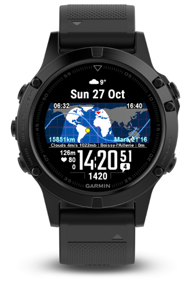
WorldFace is a watchface for Garmin devices. It features a dynamic map and highly customizable information fields that can update regularly via internet.
Default configuration
Upon first installation, WordFace shows the following screen.
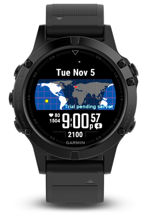
If red triangle is not displayed, it means that the watch face doesn't have your GPS location. Refer to the FAQ to get a GPS location.
After first contact with server, the screen is updated as follows. This may take 5 to 30 minutes. The watch face indicates days remaining in your trial period.
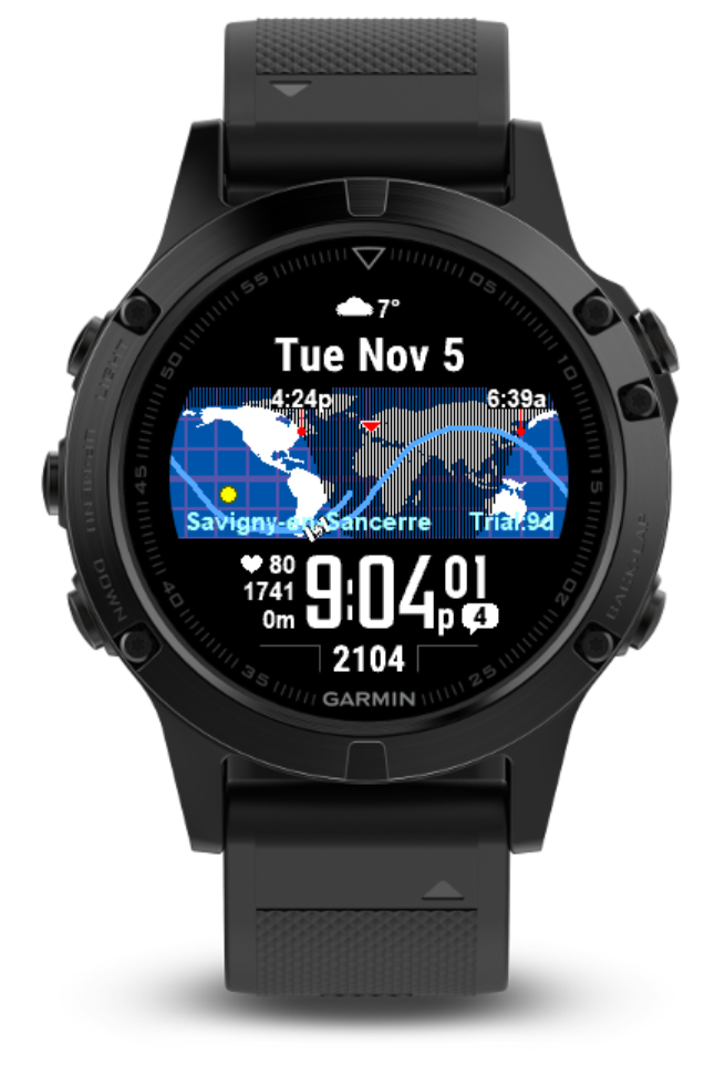
If "Trial pending server" stays for more than 30 minutes, ensure GPS location is recorded by watchface (refer to the FAQ) and internet is available.

Example customization
You are able to fully customize WorldFace. Here is an example.

All fields can be fully reconfigured in user settings (read below).
To get instructions on how to access user settings, see Garmin's tutorial.
Map

Static map
The map's static part includes:
- Background
- Latitude/longitude grid
- Continents
These map features can be set to different colors in user settings.
Dynamic map
The map's dynamic part includes:
- User location
- Sunrise and sunset (located on the map for the user latitude)
- Sun with day/night terminator
- International Space Station (ISS) and its orbit
- Status icons on either side of the screen
User location is only displayed if the watchface has successfully captured the user location. To capture a user location, go to a separate app or widget that uses GPS, and get a GPS fix. Once this is done, go back to the watchface. It should now show the user location on the map.
Should that process fail, there is a manual workaround: in user settings, set Location Source to Manual, and set Latitude and Longitude to your selected location.
Sunrise and sunset are only displayed if user location has been captured by the watchface.
Sun with day/night terminator shows the location of the sun and of the separation between day and night on the map.
International Space Station and its orbit are represented on the map by a satellite icon and a curved line. Either item can be deactivated in user settings. ISS orbit line color, width and length (in minutes) can be set in user settings. The ISS takes 90 minutes to orbit the Earth, so a setting of 180 minutes shows 2 orbits.
Status icons
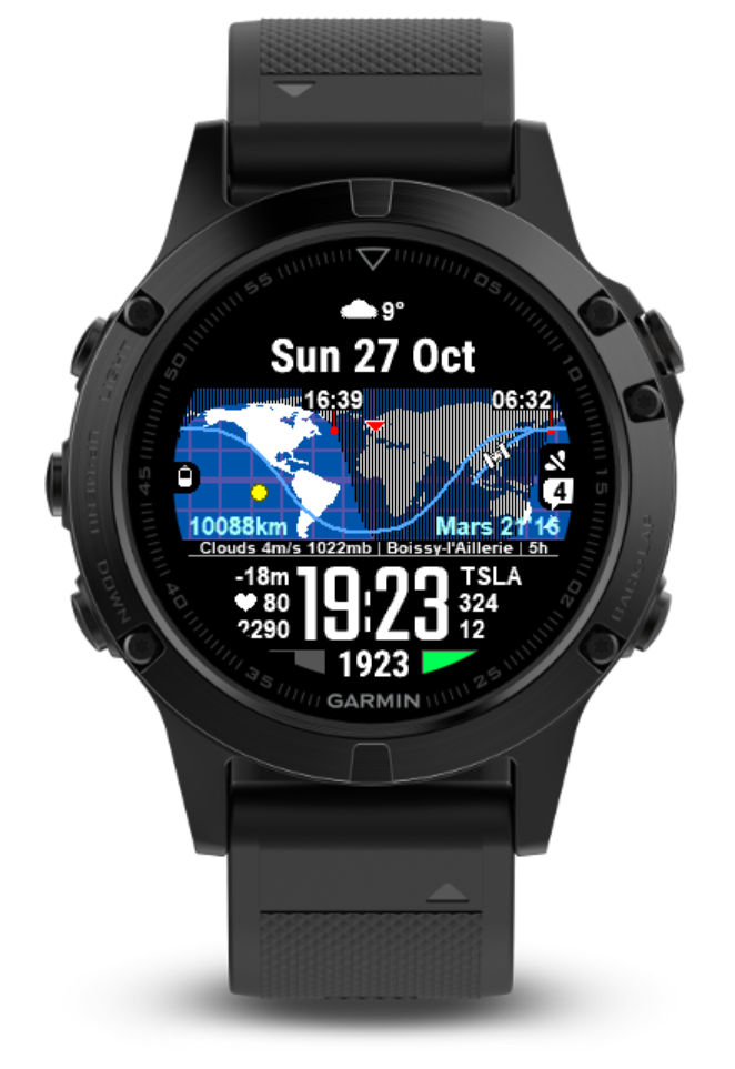
Battery icon and charge percentage can be displayed on the left side of the map under certain conditions. A battery icon is displayed if the battery % is below a certain threshold set in user settings. Furthermore, a battery percentage in numbers is displayed alongside the battery icon if the battery % is below another threshold set in user settings. Recommended: icon below 40% and percentage number below 20%. This helps declutter the screen while still effectively warning the user about battery charge.
When charging, a lightening icon and the charge percentage is displayed in place of the battery icon.
Other status icons can be displayed on the right side of the map, or near the seconds number, under certain conditions. These icons include Phone Not Connected, Notification Count and Do Not Disturb.
Fields

13 different fields are available for user customization. Any combination of information can be displayed in these fields.
- Fields Top 1, Left 1/2/3 and Right 1/2/3 can be enlarged from tiny to small font in user settings. This disables Left 2 and Right 2 as there is not enough screen real estate to accomodate them.
- Field Top 2 changes its size automatically depending on content width.
- Field Map Left, Center and Right colors can be set in user settings.
- Field Right 1/2 is only displayed if Show Seconds is disabled in user settings. This also moves the Phone Not Connected icon to the right side of the map.
- If Field 3 is empty (as set in user settings), Notification Count and Do-Not-Disturb icons replace Field 3. Otherwise, Notification Count and Do-Not-Disturb icons move to the right side of the map.
- Field Map Bottom Line completely disappears when empty, giving the watchface a cleaner look.
User settings
In the future, this section will have detail for each user setting.
This is a snapshot of user settings applicable for version 1.3.0.
Below image is outdated for 1.3.3. An update will be provided as soon as possible. Changed: some fields have been removed for memory management purposes.

User settings can be found in the Garmin Connect app on your phone, or in Garmin Express on your laptop.
To get instructions on how to access user settings, see Garmin's tutorial.
Colors
In any color field, you can input a number from 0 to 333 to select the color of your choice.

In case you are interested, the code is "RGB" (Red, Green Blue), with each number going from 0 (no color) to 3 (full color).
Datapoints
Inserting Datapoints in fields
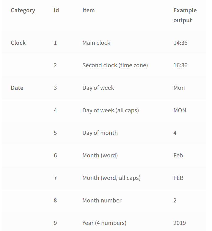
In user settings, in any given field, input the Id number of the required datapoint. For example, if you want to set Bottom Field to "Second clock", then set Bottom Field to "2".
Datapoints
Visit settings codes page for full list of datapoints.
Concatenation
Any field can contain more than one datapoint. To achieve a string of datapoints, use "+" to concatenate datapoints Ids. For example, to get Altitude (Id is 30) and Altitude unit (Id is 62), input in the field "30+62". This field will display "1252m" if the sensor altitude is 1,252m and the watch altitude unit is set to meters.
Any field can also contain manual text. For example, to display the date in a given field, it is necessary to insert spaces (to get "Mon 5 Oct" and not "Mon5Oct"). You can insert manual text separated by "+". For example, to get "Mon 5 Oct", set the field to "3+ +5+ +6".
Services
Weather
Current weather at user location is provided for a yearly fee (purchase here). The refresh rate is 30 minutes. If your watchface fails to get fresh data, it will retry 30 minutes later. However, if stock service is also active, it will retry 5 minutes later.
Forecast service will be coming up but is not yet available.
Stock market
Stocks for selected tickers is provided for a yearly fee (purchase here)
Stocks and Foreign exchange are included. The refresh rate is 5 minutes.
ISS
The ISS service is free of charge and includes the ISS orbit and current location, as well as launches to the ISS, which are displayed from 24 hours prior to a launch planned date to 15 minutes after a launch planned date.
Orbital elements will be updated twice per day. If the watchface is unable to get fresh data for about 3 - 5 days, the ISS location and orbit will no longer be accurate.

Battery life
Battery life may be affected due to the following factors:
- Any downloaded watch face runs as on a virtual machine on the watch - this additional layer requires more energy than the stock watch faces that run natively in the OS code.
- WorldFace is a complex program and might take a little bit more energy than a simple watchface
- It normally runs only once per minute unless you use gesture (in that case, it runs once per second for 8 seconds), like any other watch face
- Background processes have a high refresh rate (5 minutes for stock, 30 minutes for weather).
It is estimated that battery life may be reduced by a factor of 2 compared to a native watch face.
Energy saving mode
In order to mitigate this issue, an Energy Saving mode is available in user settings. It enables a minimal watch face to be displayed when user is not looking at the watch. Upon gesture (bring the watch in front of your face), the normal display appears.
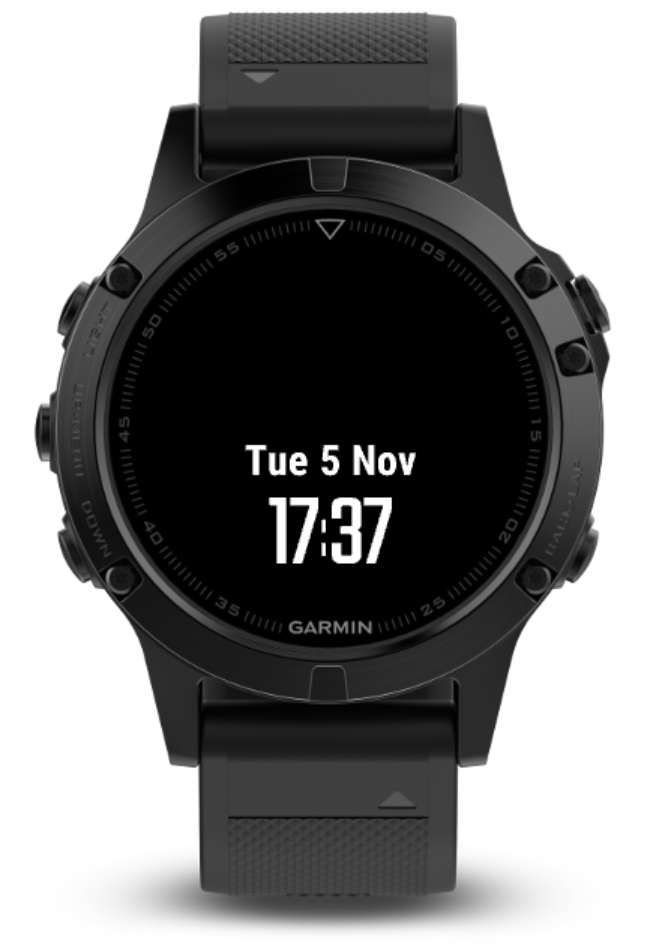
As a result, almost no computation power is used when the watch face is energy saving mode.
Settings codes
Important change since version 1.4.4 (31 Jan 2021)
Prior to version 1.4.0, code delimiter was the + sign. From version 1.4.4, the delimiter is either the + (plus) sign or the * (star) sign.
Acceptable: 5+ +6+ +7
Acceptable: 5* *6* *7
What is a datapoint?
A datapoint is a piece of information that you can choose to display on any field of the watchface. For example, the temperature, the number of calories or the stock price are 3 different datapoints. You can also choose to display fixed text, like your name, on any field.
Inserting a datapoint or text in a field
In user settings, in any given field, input the Id number of the required datapoint (example: "2"). You can also insert fixed text instead (example: "Hello, WorldFace").
Note: If you want to input fixed numbers (example: "12345"), you need at least one non-number character in that number string, such as a space (example: " 12345"). Otherwise, the number string will be analyzed as a datapoint, not as fixed text.
Combining datapoints in a field
Concatenate datapoints using the operator "*". You can concatenate both datapoints and fixed text as many times as required in any given field.
Examples
| Intent (what you want to see on your watchface) | Code (what you need to input in the field in user settings - do not input the quotes!) | Explanation |
| 16:36 Second clock | 2 | 2 is code for the second clock |
| Mon 4 Feb Date | 3* *5* *6 | 3 is week day, 5 is day and 6 is month. The * operator is used to separate codes and text. Spaces are used to separate the 3 datapoints so it doesn't show "Mon4Feb". |
| Temp: 35° Temperature | Temp: *17*60 | 17 is for temperature and 60 is for the degree symbol. The degree symbol can't be written with "°", it has to be code 60 due to limitations of the Garmin system. A fix text (Temp: ) is added and separated with the * operator. |
| T325.7 T for TSLA stock, 325.7 is the price | 20.01*21.4 | 20 is for stock ticker for the 1st ticker set in user settings. "20.01" will only show the first character (01 for the first character, 08 for 8 characters...). 21 is the stock price for the 1st ticker. "21.4" will show 4 significant numbers, so 325.7. |
| Mars 12'54 Light time to Mars | Mars *80 | The text "Mars " is inserted first and then the code 80 represents the time it takes for light to go from Planet A to Planet B. Those two planets are set to Earth and Mars in user settings. |
Datapoints
| Category | Id | Item | Example output |
| 0 | Empty | ||
| Clock | 1 | Main clock (not used) | 14:36 |
| 2 | Second clock (time zone) | 16:36 | |
| Date | 3 | Day of week | Mon |
| 4 | Day of week (all caps) | MON | |
| 5 | Day of month | 4 | |
| 6 | Month (word) | Feb | |
| 7 | Month (word, all caps) | FEB | |
| 8 | Month number | 2 | |
| 9 | Year (4 numbers) | 2019 | |
| 10 | Year (2 numbers) | 19 | |
| 11 | Week number (attempt, number may be wrong depending on some settings) Since 1.3.16 | 52 | |
| Health | 12 | Step count | 841 |
| 13 | Step goal | 1500 | |
| 14 | Step percent to goal | 41 | |
| 15 | Floor count | 4 | |
| 16 | Floor goal | 15 | |
| 17 | Floor percent to goal | 35 | |
| 18 | Calories | 531 | |
| 19 | Distance (unit: watch settings) | 0.31 | |
| Stocks | 20[.xx] | Stock 1: Ticker (xx is an optional two-digit number. It represents the number of characters to include of the ticker text, from 1 to 99. To set 5 characters, you need to write "20.05". Only write "20" for the whole ticker text) | TSLA |
| 21[.x] | Stock 1: Price (x is an optional one-digit number. It represents the number of significant numbers of the Price, from 1 to 9. To set 4 significant numbers, you need to write "21.4". Only write "21" to round to an integer) | 324 | |
| 22 | Stock 1: Age of data | 5m | |
| 23[.xx] | Stock 2: Ticker (see Stock 1 for details) | EURUSD | |
| 24[.x] | Stock 2: Price (see Stock 1 for details) | 1.11 | |
| 25 | Stock 2: Age of data | 5m | |
| 26[.xx] | Stock 3: Ticker (see Stock 1 for details) | GOOG | |
| 27[.x] | Stock 3: Price (see Stock 1 for details) | 1265 | |
| 28 | Stock 3: Age of data | 5m | |
| Sensors | 30 | Altitude (unit: watch settings) | 1252 |
| 31 | Barometer pressure (unit: user settings) | 982 | |
| 32 | Heart rate (bpm) | 64 | |
| 33 | Heart icon (not applicable to map bottom line field due to size) | ♥ | |
| 34 | Internal temperature (unit: watch settings) | 14 | |
| Location | 42[.x] | Latitude (x is an optional one-digit number. It represents the number of significant numbers of the Latitude, from 1 to 9. To set 6 significant numbers, you need to write "42.6". Only write "42" to round to an integer) | 44.2413 |
| 43[.x] | Longitude (x: Refer to Latitude) | -12.5372 | |
| Current weather* | 50 | Weather icon (not applicable to map bottom line field due to size) | ☼ |
| 51 | Weather temperature (unit: watch settings) | 35 | |
| 52 | Weather pressure at sea level (QNH) (unit: user settings) | 1021 | |
| 53 | Weather wind speed (unit: user setting) | 8 | |
| 54[.x] | Weather wind direction (x is an optional one-digit number. It represents the type of wind direction text. 54: numbers in degree (from 0 to 359) 54.1: cardinals 1 character (N, E, S, W) 54.2: cardinals up to 2 characters (N, NE, E, SE, S, SW, W, NW) 54.3: cardinals up to 3 characters (NNE, ESE, etc...) Since version 1.3.6 | 200 | |
| 55[.xx] | Weather text (xx is an optional two-digit number. It represents the number of characters to include of the weather text, from 1 to 99. To set 12 characters, you need to write "55.12". Only write "55" for the whole weather text) | Sunny | |
| 56[.xx] | City (reverse geocoded from Lat, Lon by weather service) (xx: Refer to weather) | New York | |
| 57 | Country (reverse geocoded from Lat, Lon by weather service) | US | |
| 58 | Age of weather information | 15m | |
| Units | 60 | Degree symbol | ° |
| 61 | Temperature unit (unit: watch settings) | C | |
| 62 | Wind speed unit (unit: user settings) | kt | |
| 63 | Altitude unit (unit: watch settings) | m | |
| 64 | Pressure unit (unit: user settings) | mb | |
| 65 | Distance unit (unit: watch settings) | km | |
| Forecast weather* | 70 | Weather icon | ☼ |
| 71 | Weather temperature (unit: watch settings) | 35 | |
| 72 | Weather pressure at sea level (QNH) (unit: user settings) | 1021 | |
| 73 | Weather wind speed (unit: user setting) | 8 | |
| 76 | City (reverse geocoded from Lat, Lon by forecast service) | New York | |
| 77 | Country (reverse geocoded from Lat, Lon by forecast service) | US | |
| 78 | Time elapsed since last forecast data download | 4h | |
| Space | 80 | Light time between planets Set planet A and B in user settings In light minutes'seconds (mm'ss) Want to see the solar system map? Check this widget. | 12'54 |
| 81 | Distance to ISS from user location (in km or mi, unit: watch settings) | 12635 | |
| 82 | Moon phase icon Since version 1.3.6 | 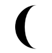 | |
| Status | 90 | Application Version | 1.3.0 |
| 91 | Trial/Premium status 1. "Trial pending server" indicates that the watchface hasn't yet been able to activate the trial period with the server. Get GPS position if this stays more than 30 minutes. 2. "Trial:3d" for example indicates 3 days are remaining in the trial period. 3. "Trial expired" indicates that the trial is expired. This message will disappear after 24 hours. 4. "Premium OK" indicates Premium is valid. | Trial:3d or Premium OK | |
| 92 | Status icons (Bluetooth not connected, Do-not-disturb/Notifications, battery) This will remove status icons from other parts of the screen. Since 1.3.16 | ||
| 93 | Battery % Since 1.3.16 | 58 |
*Current weather is only applicable to WorldFace. Forecast weather is only applicable to WeatherFace, another watchface currently only available for D2 Charlie devices. Forecast will be added to WorldFace if memory limitations are not exceeded.
Colours
In any color field, you can input a number from 0 to 333 to select the color of your choice.
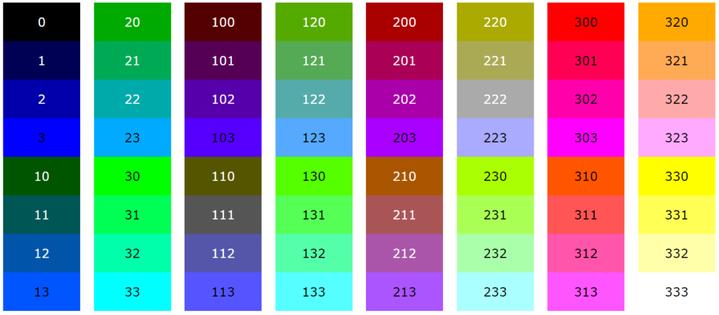
In case you are interested, the code is "RGB" (Red, Green Blue), with each number going from 0 (no color) to 3 (full color).
FAQ
My premium key isn't recognized, still displays Trial or Trial expired
I set my premium key in settings, but the watchface still displays "Trial expired" or "Trial: x days".
It may take up to 30 minutes (or even 24 hours if you have deselected weather and stocks) for the watch face to check in with the server. Your watch needs to be connected to the internet.
If the watchface still doesn't activate, then contact info (at) julienslab (dot) com.
Weather / Stocks don't appear despite entering keys
I purchased and entered my keys in user settings, but I can't see the weather information (it just displays an empty field with a ° sign) or the stock information.
Follow the steps below to solve the issue. These steps resolved 99% of the cases in the past.
- Check that your location is identified by a red triangle on the map (see next FAQ item below to solve). This is needed for weather information.
- Check that your watch has internet connection (barred bluetooth icon should not be displayed, notifications should appear if that option is activated)
- Check that your keys and email are entered properly in user settings. There should be no extra space or characters in the key/email fields.
- If none of that works, some users reported that uninstalling and reinstalling the app solved the issue. (after reinstalling, wait up to 30 minutes for weather or 5 minutes for stocks if you have internet connection)
- If you still have an issue, contact developer: [info at julienslab dot com].
My user location isn't displayed / GPS location is not detected
My user location isn't displayed on the map with a red triangle. My GPS location is not detected by the watchface.
There are two ways to solve this: GPS and manual.
First way: GPS
- Go to any app or widget that uses GPS.
- Get a GPS fix.
- Once GPS fix is established, go back to WorldFace.
- A red triangle should appear at your location, to indicate that your location has been detected.
For some users, this will still not work. The following steps have managed to overcome this issue for some users:
- Go to any app or widget that uses GPS.
- Get a GPS fix.
- Once GPS fix is established, go back to WorldFace.
- Before WorldFace appears (it normally takes 2 seconds), press the down/up button to access the nearest widget.
- Once you reached the widget, go back to WorldFace.
- A red triangle should appear at your location, to indicate that your location has been detected.
Second way: Manual
- Go to user settings (by using Garmin Express on your laptop or Garmin's app on your smartphone).
- Set "Location" to manual.
- Set "Latitude" and "Longitude" to the location of your choice.
User settings fail
There may be an issue combining Android/Apple Garmin Connect app and WorldFace. It could be that the large number of user settings make it unmanageable for Garmin Connect to pass the data without crashing.
The more recent Garmin app Connect IQ Store is designed specifically as an app market place, and seems to work normally with WorldFace.

Download Garmin Connect IQ Store: Android / Apple

Why the trouble of setting codes rather than simple drop-down menu?
Agreed, drop-down menus would be much more user-friendly. This solution was implemented initially. However, we got significant user feedback, requesting deeper customization options.
Setting codes appear to be the only technical solution that allows a very deep level of customization. Each of the 13 fields can be configured with any combination of the 50+ datapoints, plus any text. This gives more than 1000 combinations to choose from, as opposed to just 20 in the previous system.
Example for setting codes?
I don't understand how settings codes work.
For example, the setting "Calories: +18" will display: "Calories: 2319" on the watch face, if the number of calories is 2319 at that time. This is because 18 is the code for Calories.
See other codes here.